Navigation for ACA Instructor Certification Classes
Navigation: How to Use a Compass: The basics of how to use a compass. It includes definitions of the parts of a compass.
How to Read a Marine Chart Part 1: Learn the difference between a chart, a map and topo maps. Learn the basics of how to read a chart.
How to Read a Marine Chart Part 2: Learn the nitty-gritty details of reading a chart. Learn about what all those little numbers are all over a chart, learn about markers, buoys and lights. Learn about tidal features, shoreline and seabed features.
Course, Bearings and Headings: Learn about the difference between each of these terms and how they work in the real world.
Tides :
- https://paddling.com/learn/understanding-tides/
- https://tidesandcurrents.noaa.gov/noaatidepredictions.html?id=8677832
- https://tides.mobilegeographics.com/locations/3725.html
Next
Understanding Magnetic Deviation: Magnetic deviation can make all your readings incorrect. Learn how to detect it and to correct for it.
Navigation: Variation and Declination: These magnetic forces are present throughout the world and can change your compass reading. Learn how to account for variation or declination in the area you’re taking a trip in so that you can match your readings to the map or chart.
Further Reading :
- Sea Kayak Navigation by Franco Ferrero, 2007
- The Art of Kayaking by Nigel Foster, 2017, specifically Chapter 5 – Dry Skills Foundation for Trip Planning
Lastly :
Print Your Own NOAA Charts: Learn how to find and print NOAA charts for free. This can save your 1000s of dollars.
NOAA Marine Chart Converter: Learn how to use a free and open source tool to convert NOAA charts into usable image files that you can print at home.
If you have some navigation tools ie: compass and any other interesting navigation things please bring with you and we can discuss.
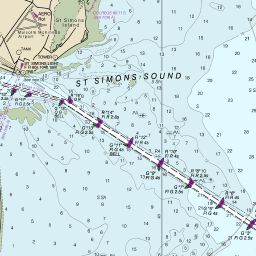
Jekyll Charts & Here
Carolina Beach, NC Charts Here
Annapolis, Md Charts Here
Amelia Island to St Augustine, Fl Charts Here
Tampa / St Pete, Fl Charts Here
Massive Chart Finder Tool
Thank you to Paddling Light
for use of this information. Please
visit for many fine articles